6 May 2026 · Bruce Hearder · 7 min read
reading-the-groundHidden in Plain Sight: 5 Overlooked Gold Zones in Historic Workings
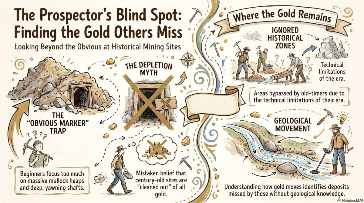
The five most overlooked gold zones in historic Western Australian mine workings are:
- Unprocessed low-grade mullock dump margins,
- Hanging wall split veins,
- Ephemeral creek wash outs directly below old battery sites,
- Divergent surfacing line-of-lode indicators, and
- Ancient dry blower tailing footprints.
There is one specific habit that separates the professional prospector from the hobbyist: the ability to recognize "blind spots" in historic goldfields. Most beginners walk straight past high-yield targets because they focus on the obvious markers—the massive mullock heaps or the deep, yawning shafts. They operate under the mistaken assumption that if a site was worked a century ago, it must be "cleaned out." In reality, gold is often missed not because it isn't there, but because it is hidden in zones that were either ignored by old-timers due to the limitations of their era, or are bypassed by modern prospectors who lack a geological understanding of how gold moves. By linking historical mining logic with modern soil science, you can identify high-probability spots that have remained untouched for over a hundred years.
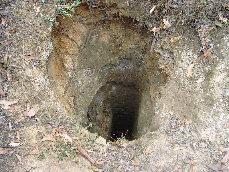
1. The "Grass Roots" Zone: Why the Collar of Old Shafts is Underdetected
When historical miners sank a shaft, they were chasing primary mineralization—the high-grade reef gold located deep in the bedrock. To reach the hard rock below, they had to bypass the top meter of soil, often referred to as the "grass roots" zone.
Because their objective was the deeper reef, this shallow material was frequently pushed aside as "overburden" and left uncrushed and unpanned.
This zone often contains significant eluvial gold—gold that has weathered out of the reef and remained near the source, moved only slightly by gravity and soil creep rather than water.
Modern detectors excel in this shallow, rocky environment, which was effectively invisible to the miners of the 1890s.
Practical Tip: The Collar Search
The 3-Meter Radius: Systematically detect a 2-3 meter radius around the "collar" (the surface edge) of every shaft. Use a small coil to navigate the irregular, rocky terrain.
Safety First: Do not trust the stability of an old shaft. Use your pick to probe the ground as you approach, looking specifically for undercut erosion where the soil has washed away beneath the surface. Never stand on the immediate edge.
The "Lack of Glamour" Problem
Most beginners start detecting 5–10 meters away from a shaft, either due to safety concerns or the assumption that the "immediate" area was worked to death. However, because the old-timers were hyper-focused on the underground prize, this immediate surface zone is frequently the most productive spot on the lease.
2. Gravity’s Path: The Downslope Colluvial Secret
Mullock dumps are the most prominent features of any historic field, acting as a magnet for prospectors. However, focusing solely on the dump itself is a tactical error. Because gold has a high specific gravity (roughly 19 times heavier than water), it doesn't stay put. Over the last century, decades of rainfall and erosion have moved heavy gold from these piles into the surrounding soil.
Identifying the Target Zone
This movement is known as colluvial wash—a slow, gravity-driven migration of material downhill. The gold hasn't moved in a sudden flood; it has settled into the "ordinary" dirt immediately downslope.
Remember: The gold won't have moved far, but even 5–15 metres downslope from the toe of the dump can put you onto previously unsearched ground.
Common Mistake: The "Dump Distraction" The most common mistake is ignoring the surrounding flat ground because it doesn't look like a "working." While the dump is the obvious target, the ground 5–15 meters downhill is often the better bet because it has never been detected or dry-blown.
3. Mind the Gaps: The Untouched Ground Between Claims
Historical goldfields were rarely operated as single, continuous mines. Instead, they were a patchwork of individual claims governed by the strict regulations of the Wardens' Court. Miners were legally and physically restricted to their own "patch." Because of the sheer physical difficulty of hand-trenching and the litigious nature of claim boundaries, narrow strips of ground between lines of shafts were often left entirely untouched.
Mapping the Gaps
When you encounter a line of workings, do not assume the entire area was gridded. Instead, "map" the site in your mind or on a GPS. Look for gaps where there is no evidence of dry blowing or surface disturbance. These gaps often represent ground that fell between the cracks of 19th-century lease boundaries or was simply too difficult to work by hand at the time.
Geological Reflection Old workings show you where people did work, but they are not an exhaustive map of where the gold exists. In a crowded field, these untouched "gaps" represent the highest-quality opportunities for finding gold in its original, undisturbed context.
4. Tracing the Source: Moving Uphill from Alluvial Heaps
There is a powerful instinct to follow gold downhill, assuming that if a nugget is found in a wash, more must be further down the gully. In reality, alluvial gold travels in only one direction. If you find yourself at the base of a dry blowing heap, you are at the end of the trail.
The Pro Move: Following the "Tail" to the "Head" Professional prospecting relies on tracing the "alluvial tail" back to the "primary source."
If a dry blowing operation was successful, that gold eroded from a reef or zone of enrichment higher up the slope. "If you're already at the bottom, going further down usually gives diminishing returns. So, do what the professional prospectors do. "Go uphill and look for the source."
Analysis: Why Synthesis Beats Luck Geology-driven prospecting consistently outperforms random searching. By identifying the topography and following natural drainage lines back toward the high ground, you can locate the "source" zone—the area where the gold originally shed from the reef. This zone may contain substantially more gold than the scattered alluvial deposits found in the heaps below.
5. The Digital Prospector: Using Historical Data as Your Compass
Success in the field begins at the desk. Not all historic sites are equal; some were abandoned due to inefficiency, while others were worked until they were truly barren. Accessing objective data allows you to bypass the "popular" spots that have been detected for forty years.
Tools for Geological Synthesis
MINEDEX: This is your source for objective production numbers. A site that recorded 100 ounces in 1897 but was quickly abandoned is a high-value target.
WAMEX: This database contains old exploration reports and drilling logs. Look for "drill intercepts" or "abandoned shallow pits" that didn't make it into a full-scale mine—these point directly to the "gaps" mentioned earlier.
GoldProspectingWA.com: Use this to overlay historical mine locations with modern tenement status and soil data.
Data vs. The "Guy at the Pub" Relying on local anecdotes is a gamble. The "bloke at the pub" will tell you about the spots everyone knows.
Historical records, however, have no ego. They provide the raw facts: what was produced, when, and by what method. Targeting a site based on 19th-century production stats rather than modern popularity is the hallmark of a professional.
The Research Advantage Old workings are powerful indicators, but they are not guarantees. The modern prospector’s edge lies in the details: the unworked shaft collars, the downslope colluvial wash, the legal gaps between claims, and the uphill sources of alluvial heaps.
The most productive trips do not begin with a shovel; they begin with a map and a plan to target the specific "blind spots" that others have missed. Before your next outing, ask yourself: are you following the crowd to the obvious piles, or are you using geological logic to find the gold they left behind?
Ready to find your next target? Visit GoldProspectingWA.com to check historical mine locations, overlay tenement status, and analyze the geology of your next prospecting site.
Former exploration geologist with 10 years of professional gold exploration in Western Australia and nearly 35 years as a recreational prospector. Read his full story →