22 March 2026 · Bruce Hearder · 10 min read
reading-the-groundThe Ground Is Lying to You — And It's Costing You Gold
Most WA prospectors are detecting the wrong layer.
Not the wrong region. Not the wrong tenement. The wrong layer — as in, the actual geological material their coil is swinging over. And the frustrating part? The right layer is almost always right there, a few metres away, looking utterly unimpressive.
Here's the setup: nearly every gold nugget ever found in WA's goldfields came from a soft, pale, crumbly layer of clay sitting beneath the surface. Not from ironstone. Not from quartz reefs. From cream-coloured clay that most prospectors walk straight past on their way to something that looks more "geological."
Understanding why changes everything about how you read the ground. And the story starts about 300 million years ago.
WA's Dirty Secret: The Ground Under Your Boots Is Ancient
The Yilgarn Craton — the chunk of ancient continental crust that underlies most of WA's goldfields — is one of the oldest, most geologically inert pieces of rock on the planet. No glaciers have scraped across it and reset the clock. No mountain-building events, no continental collisions, no major erosion cycles have reworked the surface. It's been sitting there, essentially untouched, for billions of years.
That stability has one extraordinary consequence: the weathering process has had an almost completely uninterrupted run for hundreds of millions of years. And the result is a zone of chemically transformed material — called the regolith — sitting above the fresh bedrock that can be 100 metres thick in places.
Not five metres. Not ten. One hundred metres deep. That's a twenty-storey building of chemically altered rock sitting between you and the fresh stuff below.
Your metal detector, on a good day in good ground, reaches about one to two metres.
Let that gap sink in for a moment.
The Engine That Built It (And Why It's Not What You Think)
Here's the part that rearranges your brain a little: the laterite profile under Kalgoorlie, Leonora, and Meekatharra wasn't built by the climate you drove through to get there. It was built by a completely different world.
Hundreds of millions of years ago, WA sat much closer to the tropics. The climate wasn't semi-arid scrub — it was monsoon. Think far north Queensland, but more intense, running continuously for tens of millions of years. Torrential rainfall plus high temperatures equals the most aggressive chemical weathering process nature has available.
Rainwater falling through that ancient atmosphere picked up CO₂ and turned mildly acidic. That weak acid attacked the rock — dissolving feldspars, destroying iron sulphides like pyrite, flushing soluble minerals down and away through groundwater. What couldn't be dissolved stayed behind: iron oxides, aluminium oxides, silica. Over millions of wet seasons, that insoluble residue accumulated and deepened.
The climate eventually dried out. WA became the semi-arid landscape you know. But the profile that tropical engine built is still sitting there, perfectly preserved by the same geological stability that allowed it to form in the first place.
You're detecting ground that was shaped by a world that no longer exists. The present is not always the key to the past.
Don't look at today's dry conditions and assume weathering has always been slow. The profile beneath your boots was built during a completely different era, and it's been sitting there waiting ever since.
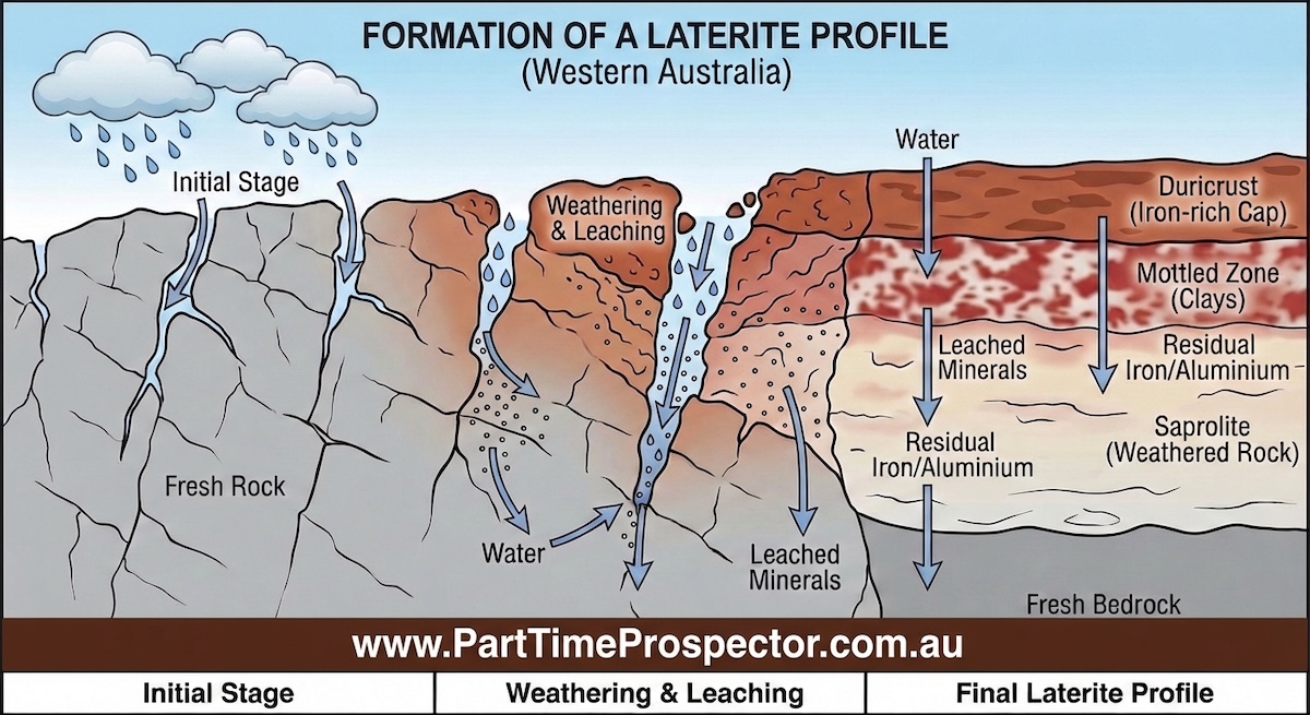
Reading the Profile: What Each Layer Is Telling You
The regolith isn't random. It's a stack of distinct zones, each with its own character — and its own relationship with gold.
Fresh Bedrock is at the bottom. Unweathered, hard, original mineralogy fully intact. Gold here is locked inside reefs and sulphide minerals. This is the source. It's largely inaccessible to a detector and rarely exposed except in deeply eroded terrain.
Saprock sits directly above the fresh rock — the transition zone where weathering begins. The rock still holds its structure, but minerals are starting to break down. This is where gold mobility starts: as sulphides begin to dissolve, they begin releasing the gold trapped inside them.
Saprolite is where the gold ends up, and we'll come back to this in detail. It's the soft, clay-rich, pale-coloured zone sitting above the saprock — and it's the most important layer a WA prospector can learn to recognise.
The Mottled Zone sits above the saprolite: red, yellow, and white patches where iron is being redistributed upward through the profile. Less consistent for gold, but a useful marker — if you can see mottling in a creek bank, the productive saprolite is just below it.
The Ferruginous Duricrust — or laterite cap — is the rock-hard, iron-stained, reddish-brown surface crust you already know and hate. It's the layer that defeats your pick and pulls your detector signal. Almost every prospector spends most of their time swinging a coil over this layer.
Almost no nuggets come from it.
The Duricrust: You're Detecting a Lid
The duricrust is not where the gold lives. It's what's sitting on top of where the gold lives.
Here's how it forms. During dry seasons, water is drawn upward through the profile by capillary action — the same way water wicks up a dry cloth. That water carries dissolved iron in solution. At the surface, the water evaporates and the iron precipitates out, cementing the near-surface material into a dense, hard layer. Run that cycle continuously for tens of millions of years and you get what you're driving to: the thick, durable, maddening cap across WA's goldfields. Those little ball-bearing pisolithic ironstone pebbles scattered everywhere form the same way — iron precipitating around a nucleus until it becomes its own small armoured package.
The duricrust is useful information, though. Its presence tells you the full productive profile is almost certainly intact beneath it. Where it's thick and undisturbed, the saprolite gold beneath it is deeper — hard to reach, possibly out of detection range entirely. Where the duricrust is thin, broken down, or absent — where erosion has punched through it — the saprolite is close to the surface. That's where you want to be.
Most beginners do the opposite. They detect flat duricrust plateaus because they look accessible and the ironstone is obviously something. The gold is below the lid, and you need to find where the lid has been removed.
Saprolite: The Layer That Built WA's Gold Rush
If you take one thing from this article, take this: learn to recognise saprolite, and get excited about it every single time you see it.
Here's the mechanism. Gold was originally locked inside sulphide minerals — mostly pyrite — distributed through the original host rock. Chemical weathering destroys those sulphides. As pyrite breaks down, the gold that was imprisoned inside it is physically freed. That liberated gold is chemically inert — it doesn't dissolve, doesn't react, doesn't go anywhere the way everything else does. As the rock structure around it collapses into clay, the gold becomes mechanically concentrated in the residual material. And in many cases, freed gold continues to grow in the weathering environment — secondary gold can develop into larger, more irregular, more detectable nuggets than the original mineralised source.
This is why WA nuggets are typically coarse, rounded, and sitting in clay rather than locked inside hard rock. The weathering process concentrated and enlarged them over millions of years. It ran a 300-million-year gold processing operation, and the saprolite is the output.
In the field, saprolite is soft and crumbly. It's clay-rich. The colours are pale — cream, white, light grey, pale yellow. And it often shows relict fabric — ghosted outlines of the original rock structure, visible even though the material is now soft enough to scratch with your fingernail. You can see where the original rock was, preserved in the clay like a memory.
It's exposed wherever erosion has stripped back the surface: creek banks, gully floors, road cuts, eroding hillslopes. Run your detector carefully along those exposed pale faces. That is high-probability ground.
And here's the blunt truth: a huge number of prospectors walk straight past exposed saprolite on their way to ironstone ridges. The ironstone looks like geology. It's red and hard and has that feel of mineralisation. The pale clay bank looks like nothing — drainage material, boring ground, not worth stopping for.
The pale clay bank is where the nuggets are.
This is the mindset shift that separates the prospectors who find gold from the prospectors who find ironstone. Get excited about cream-coloured clay. That's not a trivial reframe — it is the actual skill.
The Two Clocks Running Simultaneously
Understanding WA's gold distribution means keeping two timescales in your head at once.
The ancient timescale — hundreds of millions of years — explains the profile. It explains why the saprolite is where it is, why the gold is concentrated within it, and why WA's regolith is so unusually thick and productive. That ancient tropical monsoon did the work. The results are still sitting there.
The modern timescale — years, seasons, individual rainfall events — explains where gold has moved within that profile. Recent rains flush liberated gold and small nuggets downslope into drainage systems. Every wet-dry cycle continues the iron-cementation process, just far more slowly than the ancient engine ran. And a significant rainfall event can expose fresh saprolite in creek banks and gully walls that wasn't accessible before last season.
The weeks following significant rain are consistently some of the best times to be in WA's goldfields. Freshly exposed creek banks. New erosion faces. Saprolite that wasn't accessible six weeks ago now sitting right there for the coil.
Two clocks. Ancient weathering concentrated the gold. Modern weather is delivering it to the surface. Your job is to read both.
How to Use This Before You Leave the House
Before you commit to a location, ask yourself which layer you're most likely to be detecting. That question alone — which most prospectors never ask — puts you ahead of the majority.
Government drillhole data logged through WAMEX and available on platforms like GoldProspectingWA.com records regolith depths for thousands of holes across WA's goldfields. Knowing you're heading into ground with 8 metres of regolith versus 60 metres of regolith completely changes your approach. Shallow regolith means the saprolite might be within detection range. Deep regolith on flat ground means you're probably swinging over the duricrust lid and the productive zone is well out of reach — focus on drainage lines where erosion has done the work for you.
In the field, find road cuts, creek banks, and gully walls and use them as vertical cross-sections through the profile. Learn to identify each layer by eye. Once you can read the profile vertically in section, you'll start recognising what layer you're detecting when you're moving horizontally across the landscape.
The prospectors who consistently find gold aren't lucky. They're walking the same country as everyone else, but they're reading it. They walk past the ironstone ridge and stop at the pale clay bank because they know — not guess, know — what that pale clay represents.
That's the edge. It doesn't come from a better detector. It comes from understanding what the ground is telling you.
Get out there and read it.
Access daily-updated tenement maps, drillhole logs, and soil sample data for WA's goldfields at GoldProspectingWA.com — so you can identify the right layer before you even pack the car.